The general consensus amongst cruisers is that Hawaii is a wonderful transpacific destination … but not great for cruising. The reason for this is a shortage of well- protected anchorages and the omnipresent swells that frequently render the anchorages uncomfortable… or untenable. We were about to find out.
OK, we’re not talking about the inland waters of British Columbia, the Bay of Islands, New Zealand, or the protected waters of Vava’u, Tonga. But the Hawaiian Islands have much to offer. We were fortunate enough to score a digital copy of Bill Leary’s “Noodle’s Notes” of Hawaii (and subsequently meet and befriend Bill and Lori in Kaneohe Bay). Noodle describes his favorite anchorages around the state in substantial detail and offers his rich experience navigating the waters and weather of Hawaii.
After leaving Honolulu for the 2nd time, we returned to Kaneohe Bay for a few days before spending a night at Waimea and jumping across the Kauai Channel to petite Nauiliwili Harbor. Behind a substantial breakwater providing perfect protection from the prevailing E or NE trade winds. Nauiliwili is the commercial port of the island of Kauai. It isn’t picturesque but the holding is good and shore access is easy thru the small boat harbor. It’s a bit of a hike to the local Costco, Home Depot, and Safeway but we needed exercise anyway. We rented a car from Clayton at Rent-a-Wreck for a couple days of hiking and touring the island. Indeed, Kauai is the “Garden Island” of the State. Lush green rain forests, tall waterfalls, and torrential rains and flash floods characterize the Island. As an extra bonus, I discovered the joy of locking our keys in the car… at the very end of the Waimea Canyon Road…with the lights on…as nighfall approached…. without cell service. Fortunately, we met a kind couple who offered to drive us down the road 7 miles to a point where we could call AAA for help. AAA offered to send a technician in a few hours but he couldn’t give us a ride back to our car (Covid concerns). With another stroke of luck, we were able to convince a local resident with a pickup truck to run us back up the hill to await AAA… who arrived about 23:00. A lousy end to an otherwise spectacular day!
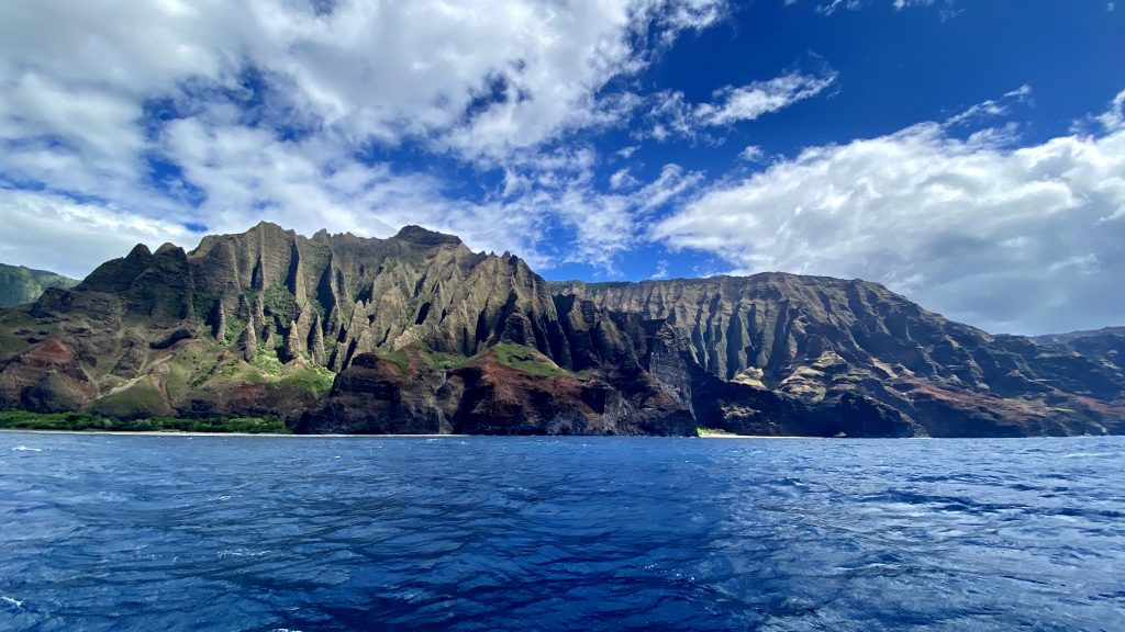
Following our visit to Nauiliwili, we sailed a few hours up the coast to beautiful Hanalei Bay on the Napali Coast of Kauai. Hanalei is a large beautiful bay with very little swell wrap from the NE and a sizable contingent of surfers making what they could of the diminutive surf. The holding is very good in sand and the extensive beach is inviting. A local grocery, liquor store, and fish market are in easy walking distance. From Hanalei, we hitch hiked to the trail head of the famous Kalalau Trail that follows the stunning coast for 11 miles to the Kalalau camp ground. We chose the short version that departs from the coast after 2 miles and proceeds another two miles up a valley, through a rain forest to an incredible waterfall. Cindy’s pictures tell the whole story… except for the chapter about her horrible hiking boots that claim their pound of flesh with each wearing. Whoever said that hiking boots wear in, doesn’t know Solomon.
There are a couple more anchorages along the Napali Coast to the west of Hanalei, but in both cases, you’ll anchor behind a small reef, protected from the prevailing swell, with your back against another reef. With trusty ground tackle and settled weather these are fine anchorages, but don’t except a comfortable, care-free night.
On the 4th of July, we set out for the private Island of Niihau, about 15 miles west of Kauai. Elizabeth Sinclair purchased the island from King Kamehameha V in 1864 for $10,000 in Gold – a huge sum at the time. It is now owned by the Robinson brothers (descendants of Ms. Sinclair) and is open only to friends and family of the Robinsons, the US Navy, and a number of native Hawaiian families. On selling the island, the King required the island remain untouched by progress – a refuge where natives can live according to the ancient Hawaiian ways. As such, the inhabitants also assert that it is forbidden to land on the island. In this assertion, they are at odds with the State Government who mandates that all beaches in the State are public property for public enjoyment. The island is reported to have no electricity, no running water, no flush toilets, no internet, no roads, no cars, etc. Population is unknown, but best guess is that about 70 people live full time on NiiHau – and they defend their privacy aggressively.
All this said, we observed otherwise. We saw the locals driving an old army/navy troop transport truck along a dirt road. They had binoculars to observe our movements. A large landing craft arrived and deposited considerable cargo on the beach where it was loaded in trucks and carried away. Cows and pigs roamed the low lands, munching on grass and rooting in the muck. We didn’t see anyone fishing or tending fields, nor didwe see the primary village. We’ve read that employment opportunities on the island are scarce – mostly limited to maintenance chores for the Robinsons. For this reason, many inhabitants leave the island for employment elsewhere. Others, we suspect, are happy to collect government unemployment benefits.
We began our visit with a night swinging on a sturdy mooring set by dive tour operators on the rocky coast of Lehua Island, a calera only a couple miles from the N tip of Niihau. Along the south shore, we found excellent snorkeling, including spottings of “Oscar” the monk seal, sea turtles and a large grey shark… who drove us back to our dinghy. We can confirm that the current really boils through the pass between Lehua Caldera and Niihau.
After a strange night laying stern to the wind and wavelets and another dinghy snorkel trip, we moved Pazzo to the Pu’ukole anchorage at the north end of Niihau. It took a snorkel dive to get the anchor to settle into a chink in the hard-pan bottom but once in the ditch, we were secure. We took a short walk along the beach, staying below the tree/scruff line. With the village in the center of the island, we went undetected on the“forbidden” beach.
In the morning, we noted a large reef a hundred meters behind the boat – odd since we hadn’t seen anything on our way into the anchorage – nor did the chart show a hazard. With masks and snorkels, we quickly realized that the “reef” was actually a very dense and HUGE ball of small fish (6” – 10” long) corralled and kept tightly packed by a dozen or so tuna, a couple of sharks, and “Oscar” the monk seal. Perhaps a banquet was in the making? Later in the afternoon, we moved the boat south a couple of miles to the Keawanui Anchorage along the western shore, putting us closer to the village. While anchoring, we noted a couple of large troop hauling army vehicles on the shore – binoculars trained our way. A bit unsettling, but nothing to interfere with a good spaghetti dinner.
At 0700 the following morning, we ventured ashore for another beach-combing walk. Within an hour, an army truck approached on a dirt road above the high tide line with locals fiercely yelling “Go Away – Leave.” I approached them with a peace offering of snorkel masks, reading glasses, and even a 12-gallon outboard fuel tank we found floating off their shore. To each offer, they responded ”NO! GOWAY!” I think that’s the opposite of Aloha. We understand that they’ve been cautioned against venturing onto the (public) beach when defending their turf.
We casually made our way back to our dink and returned to Pazzo where Cindy prepared a lovely breakfast… all under the watchful binoculars. After breakfast, we idled our way down the west coast, checking out a couple of small bays, and by noon hoisted reduced sail for the 48 hour slog SE to the south tip of the Big Island (Hawaii).
A week earlier, Noodle and friends made this easy passage with sheets cracked and beer flowing. Our trip was an upwind bash the whole way, including one tack to the NE for a spell as a squall rolled through. Uncomfortable and wet, we finally found the lee of the Big Island at 0100 of our 2nd night at sea and motored for 12 hours to Okoe Bay the south-most anchorage of the Hawaiian Islands.
Okoe is comprised of several black-sand beaches well protected from the NE trade winds. Ashore we found the remains of an ancient Hawaiian village and a well preserved toboggan hill built out of crushed lava rock. Apparently, the ancients used to race sleds down the hill covered with slippery banana leaves. A bit hard to imagine.
In Okoe, we met Maureen Gapp and a gaggle of friends enjoying “Sandy’s” cabin, the only private cabin in Okoe. After taking a large contingent of Maureen’s friends on a sunset sail along the shore, we returned to the anchorage for a lovely fish feast ashore and a quiet night at anchor.
Lying in the midst of the North Pacific, the Hawaiian Islands are exposed to swells originating from storms far away. This makes the islands a surfer’s paradise, but creates uncomfortable anchorages when the “surf’s up” from an exposed direction.
This means that Hawaii’s south-facing shores are exposed to swells from the south. So,
even when the volcanos are blocking the NE trade winds, the south shores can be rolly. We were fortunate that our visit to the Big Island’s Kona coast coincided with settled weather to the south.
After a lovely and peaceful visit to Okoe Bay, we made our way north to Captain Cook’s Bay, locally formally as Kealakekua. There stands a large and fitting monument to the great navigator near the place of his death. I’ll spare you the details surrounding the captain’s demise, but suffice it to say that his death was the result of an unfortunate situation that spun out of control.
We discovered in Kealakekua the benefit of cruising Hawaii during COVID: no tourists and no tour boats! We had the bay all to ourselves – including a few nights unbothered swinging on the only tour boat mooring in the shadow of the monument! The snorkeling here was some of the best in the islands. Warm water filled with schools of colorful fishes and a few sharks. All within about 50 meters of the boat!
From Kealakekua, we made use of the daytime onshore sea-breeze to make our way north to Honokahau Harbor, the small fishing harbor of Kona, where we lucked into an open guest slip. As a sport-fishing destination, the guest berths are nearly always full. Pazzo enjoyed a bath before we hitch-hiked to the Kona airport to rent a car for a few days of touring the Big Island. Once again, we enjoyed tourist-free Hawaii – including a hike in Hawaii’s Volcano National Park. Our (real bargain!) rental car took us for a delicious lunch with dear friends Skip and Ilze Sims (cruising friends from our 2004/5 trip) who have settled into a beautiful pole house in Hilo followed by dinner and a night with John and Maureen Gaap ( our new Okoe Bay friends).
On July 20, we slipped our lines at Honokahau and moved Pazzo a few miles south to the Kailua-Kona anchorage – a rolly place with a good dinghy dock for shore-side touring. Kona is a special place for Cindy and me: we first met here in 1978 and honey-mooned here at the Kona Sea Village, now condos. Cindy has fond memories of Kona vacations with her parents and sister. We’ve now added fond memories of daily visits by a pod of local dolphins.
On July 21, we started watching Hurricane Douglas approaching from the E and lined up directly on the Islands. While direct hits on Hawaii are rare, the Islands stand in the normal paths. Over the next couple of days we watched Douglas track directly toward the Big Island. Almost always, storms follow a SE to NW path, curving more northerly as they progress westward. On July 23, after lengthy discussions with Skip Sims, we moved Pazzo south to Okoe Boat and prepared to sail south with all speed in the event that Douglas failed to make the turn north. By getting south of the storm track we’d avoid storm force winds but would still have to cope with ugly and confused seas. July 24 dawned with most (but not all) weather models starting to show a northerly shift in Douglas’ path. With Pazzo battened down and ready for a dash south, we took a walk along the shore while waiting for the next update to weather
models and another call with Skip. If the afternoon models showed the storm tracking north of the Big Island, we’d sail north and hide in the shadow of Mauna-Kea. If the models showed a shift back toward South Point, we’d sail south with all speed.
We were relieved that the afternoon models all agreed on a more northerly track so we upped our anchor and moved Pazzo to a big sandy patch in Kealakekua Bay off the small town. Here, tall hills near the shore and, more importantly, the Mauna-Kea volcano offered to break up the storm and temper the winds if the models proved in error. Nevertheless, we set tandem anchors (2 anchors on one chain) and dove on the ground tackle to ensure both anchors were well set in the sand. And then we waited.
On July 26, Douglas passed narrowly north of the Hawaiian Islands bringing rain and strong winds to Kauai, but causing no damage. Whew! All was calm on the Kona coast as the commercial ships and tugs who’d been safely at sea to the south of the Islands returned to their home bases.
From Kailua-Kona, we sailed north to anchor in a beautiful bay that’s home to the famous Mauna-Kea Beach Resort. The resort was deserted (thanks to COVID) but the beach was buzzing with locals appreciating that all beaches are public. We found ourselves privileged to enjoy this gorgeous bay without myriad water craft killing the mood. The Beach Resort was a special place for our dear friend Peter Cohen and his wife, Indu.
August kicked off with a visit to a Historical museum and Heiau Site at Kawaihae where we enjoyed a quiet night at anchor inside the breakwater of the small boat harbor. From there, we sailed north to a lovely roadstead anchorage at Nishimura Bay. This is the northern most nick in the rugged coast that still offers a modicum of protection from the incessant NE trade winds that define the Alenuihaha Channel between the Big Island and Maui. By commencing the channel crossing from as far north as possible, sailors are able to put the wind and waves behind the beam for a more comfortable ride across the channel. We got an early start on August 3, motoring north to get the best angle on the wind. True to form, the Alenuihaha turned sporting by mid morning but by this time we were half way across and had landed a small Mahi-Mahi for dinner. By noon we were anchored under the protective lava cliffs of La Peruse Bay at the southeast tip of Maui.
To be continued in Part 2…..